loating on the surface of a cauldron | briefing document
tectonics:
tectonic plates –
floating on the surface of a cauldron
a briefing document
This page helpful?
Like it ! Share it !
Tectonics: tectonic plates – floating on the surface
of a cauldron discusses tectonic
plates, including their relationship to tsunamis. This
is a sub-document to tsunamis:
tsunamis travel fast but not at infinite speed.
“Floating on the surface of a cauldron” is not quite
the way we usually view our ship sailing in space, but this is the
reality.
Regularly, the cauldron sends up cubic kilometres of hell fire as
a reminder not to take our precarious home too casually, or a couple
of the floating islands heave like a slumbering giants turning in
a dream, as with the Sumatran earthquake.
The Earth’s surface is made up of a number of enormous rock
plates (islands) that move over the convection currents, caused by
heat from radioactive decay, in the molten rock nearer the Earth’s
centre. These plates can be as big, or bigger, than a continent or
an ocean. These movements take place over, what to a human, is enormous
periods of time. As usual, humans work to organise these incredible
time periods in a manner to help people make sense of them.
600
to present: 15% O2, below 1% CO2 in atmosphere
1,150 to present: life in the sea
1,700 to present:
free oxygen (O2), in atmosphere
438
to 410
Silurian
460 to 430
505
to 438
Ordovician
540
to 505
Cambrian
2,500 to 540
Neoproterozoic
1,000-540
800 to
600
Mesoproterozoic
1,600-1,000
3,500
to 1,150: primitive lifeforms producing an atmosphere; 20% carbon dioxide
in atmosphere gradually reducing
3,500:
oldest fossil record of life
Paleoproterozoic
2,500-1,600
4,600
to 2,000: early atmosphere virtually anaerobic with 80% CO2 concentration;
sun colder than now;
more ultra-violet radiation;
sea 1/3 present salinity
4,600
to 2,500
million years ago
archaean 3,800–2,500
2700 to
2300
hadean 4,600–3,800
the changing face of
the earth over time
The past placement of these continenets and countries cannot be thought
of as reliable in the sense of modern maps. Placing the changing landmasses
is a matter of complex detective work involving geo-magnetism, plant
evolution, geology and other clues.
tectonic
movements
As the tectonic plates move, they can
diverge, creating rift valleys
converge, occuring between a continental and an
oceanic plate
converge, occuring between two oceanic plates
converge, occuring between two continental plates
diverge, creating rift valleys
On land, a clear example is the rift valley in
Eastern Africa; while the Atlantic Ocean is the
result of two tectonics: tectonic plates moving
and being pushed apart by molten larva from the
Earth’s core. The molten rock also enlargens
the plates.
converge, occuring between a continental
and an oceanic plate
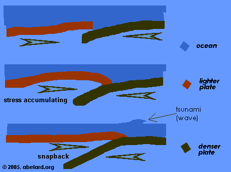
This is what has occured with Sumatran quake. The
denser oceanic plate is subducted (slides under)
beneath the lighter continental plate, lubricated
by the sea. As the oceanic plate subducts, it heats
up and generates
volcanic activity along the margin.
converge, occuring between two oceanic
plates
Here, also one plate subducts under another under
the ocean, the lower plate melting with the resulting
magma possibly pushing up to make a line of volcanic
islands along the length of the subduction.
converge, occuring between two continental
plates
This occurs when there is no sea or ocean to lubricate
the movement between the two plates, as is the case
between the Indian and the Asian plates. The Indian
plate was subducting under the Asian plate, but
instead both plates were forced upwards to form
the Himalayas.
the
Sumatran earthquake
The tectonic plates in the area of Sumatra, where
the earthquake hit on 26 December 2004, are moving
at about the speed that your fingernails grow, say
five to ten centimetres per year.
This gradual movement builds up tension over decades
(or even centuries) until, explosively, the plates
readjust – that readjustment is an earthquake.
It is these slow-moving adjustments that, over millions
of years, change the whole map of the planet: countries
move, continents move, mountains grow, rift valleys
widen and split into new land masses.
A tectonic plate slip can be a very fast, explosive
event. Think in terms of bending a stick, where the
tension gradually increases and then suddenly, the
stick snaps back. If you want to see this happen,
push a fairly thin green branch at an angle, up against
a brick or concrete wall and the stick will bend,
and then at some point the branch will slip and spring
back. (If you are youthful, don’t
do this without supervision; and if you’re more
experienced, take precautions, because the energy
when the branch snaps back can be dangerous.)
Windows Media
Player
Volcanoes form along the meeting of the tectonic
plates, hence the long strings of volcanic activity
and associated earthquakes around the planet.
“Erupting volcanoes are among the most destructive
forces in Mother Nature's arsenal. But where many
people live on or near the flanks of such mountains,
the real disaster often doesn't start until the
eruption has subsided and the world has stopped
paying attention. It is then that rain-swollen rivers
emanating from volcanic peaks can send massive lahars
- large waves of mud made up of water, ash and volcanic
rock - careening down the mountainsides, often burying
everything in their paths, even entire towns and
villages. Such lahars can occur for years after
an eruption, depending on how much debris the volcano
deposits and how much rain falls, until the sediment
has either been cleaned off the mountain or has
stabilized so that it doesn't erode easily.”
—
“In one of the streams we're studying, nothing
can live. If a big storm hits, the whole riverbed
moves," Gran said. That means that more than
13 years after the eruption, some of the rivers
studied have not recovered to the point of having
stable channels, which are necessary for a return
of aquatic species and a general ecological recovery.”
—
“Mount Pinatubo's eruption [1991], the second
largest recorded in the 20th century, deposited
nearly 1.5 cubic miles of volcanic ash and rock
on its flanks, about 10 times more than Mount St.
Helens in Washington state deposited in its eruptions
in 1980.”
The eruption of Katmai, Alsaka in 1912 was the largest
volcanic eruption of the 20th century.
“Seismologists initially used seismic waves
with periods of about 300 seconds to set the magnitude
of the Sumatran earthquake at 9.0 - making it the
fifth most powerful event on record.”
—
“ [Then they examined] seismograms taken from
7 stations around the world in the week or so following
the earthquake. They looked for the longest-period
waves possible - those lasting about 3200 seconds
(53 minutes). "We found [...] that there was
three times more energy out there than at the 300-second
period [...]" The new work reclassifies the
earthquake on the logarithmic Richter
scale at magnitude 9.3 - second only to the
9.5-magnitude quake recorded in Chile in 1960. ”
—
“The Burma plate rebounded upwards by about
10 metres at the quake's epicentre - setting the
deadly tsunami waves in motion. And the process
continued along the border between the two plates,
causing the earth to rupture along the fault line
- running from south to north. But seismologists
are not sure exactly where the rip stopped.”
once
upon a time i used to wander on this neat solid ball
of mud
Now as I was young and easy under the apple boughs
About the lilting house and happy as the grass
was green. Dylan
Thomas, Fern Hill, 1946
Now us human monkeys are beginning to wake up and
look around—
Global warming, new ice ages, AIDS and ebola, great
starvations and collapsed civilisations....
Then there are wandering asteroids set to wipe out
dinosaurs, or us. That is, of course, if we don’t
contrive to blow ourselves up first, or manage to
ruin the land and water sufficiently that it will
no longer feed us.
And by the way,
I’ve been told that we are blithely sitting on
volcanos fit to darken the sun and moon and leave
us struggling to breathe; let alone being able to
continue to live our profligate lives, while waiting
for the oil to run out in a few years.
I open the door and the flies swarm in,
Shut the door and I'm sweating again;
And in the process I cracked my shin,
Just one darn thing after another. [From Life
gits te-jus dont it, 1948]
So now folks, we have the ‘supervolcano’,
where the earth opens up and gobbles us all down,
well almost. The last one was apparently 74,000 years
ago, so the wiseacres tell me. Not very long, considering
that our written history only goes back about 10,000
years, and I’m told sommat like us has been around
half a million to a couple of million years. So these
things seem to come around every other Tuesday, whereas
the last serious asteroid was around 60 million years
ago—if I am to believe ‘them’.
“ROBERT CHRISTIANSEN: Quite amazingly we realised
that there was a cycle of caldera-forming eruptions,
these huge volcanic eruptions [occur] about every
600,000 years.
“NARRATOR: Yellowstone was on a 600,000 year
cycle and the last eruption was just 600,000 years
ago. Yet there was no evidence of volcanic activity
now. The volcano seemed extinct. That reassuring
thought was about to change.”
end notes
Ice
ages
The Ice Age column on the geological timeline above gives only a rough impression of when ice
ages occured.
Knowledge on ice ages is steadily increasing. In
recent times and back to 800,000 years ago, ice
ages have been occuring roughly every 100,000 years.
Before 800,000 years ago, ice ages were on an approximately
40,000 year cycle.
There is a lot of variation within these cycles,
most of the causal factors are at peresent speculative.
Because the
Richter scale is logarithmic, an increase of 0.3
is equivalent to a doubling of the strength of an
earthquake.
Eons,
eras, periods and epochs
The names of the geological timespans, like the classifications
used for categorising life-forms, change
as those studying the topic learn more, make
further discoveries, or try to be more precise.
And the discussions over the names contuinue.
We at abelard.org have attempted
to provide the least ambiguous namings. However,
there is a fair degree of naming confusion,
not least because older names for the same,
or for slightly different, time periods are
still being used alongside the newer names. Etymologies:
Prefixes and suffixes:
-zoic:
from zoon [Greek], meaning: life or
animal
paleo-:
from palaios [Greek], meaning: ancient,
or from palai, Greek, meaning long
ago
meso-:
from mesos [Greek], meaning: middle
neo-: from neos [Greek], meaning: new Eons:
Phanerozoic: visible or evident
life
(phaneros [Greek], meaning: visible
or evident, + -zoic)
Proterozoic: the eon before
the Phanerozoic eon
(proteros [Greek] meaning: earlier
or former + -zoic) Eras:
Cenozoic:
new life (kainos [Greek], meaning:
new or recent + -zoic)
Mesozoic: middle life/animals
Paleozoic: ancient life
Archaean: from archaea [Greek], meaning: ancient ones
Hadean: After Hades, Greek
for hell (from the intense heat during part
of this period). Periods:
Tertiary and Quaternary:
“The name Tertiary was first applied about
the middle of the 18th cent. to a layer of deposits,
largely unconsolidated sediments, geologically
younger than, and overlying, certain other deposits
then known as Primary and Secondary. Later (c.1830)
a fourth division, the Quaternary, was added.
Although these divisions of the earth’s
crust seemed adequate for the region to which
the designations were originally applied (parts
of the Alps and plains of Italy), when the same
system was later extended to other parts of
Europe and to America it proved to be inapplicable.
It was realized that one scheme of classification
could not be applied universally.
The names Primary and Secondary were generally
abandoned; Tertiary and Quaternary were, and
still are, used, but other geologic literature
substitutes other names, including the Palaeogene
and Neogene.”
[Quoted from The
Columbia Electronic Encyclopedia]
Cretaceous: from cretaceus,
Latin, chalky.
There were widespread deposits of chalk rocks
at this period.
Jurrasic: from the Jura Mountains,
which run along the border of France and Switzerland.
Triassic: from trias [Latin], meaning triad.
This period is so named for the three distinct
layers of rock laid down during this period:
continental redbeds, then marine limestone and
thirdly evaporites.
Permian: named after the
Perm region in Russia where extensive areas
of rock formed in this period are found.
Carboniferous: Producing
carbon or coal .
Extensive swampy forests in this period later
formed coal deposits.
Devonian: named after the
marine formation of Devonshire dtaing from this
period.
Silurian: from Silures [Latin], an ancient people of southwest Wales,
where the rocks were first identified.
Ordovician: from Ordovices [Celtic], an ancient Celtic tribe of Wales.
Cambrian: from medieval Latin
name for Wales - Cambria. Epochs: