Children and television violencelink to document abstractslink to short briefings documents link to news zone        news resources at abelard.org interesting site links at abelard's news and comment zone orientation at abelard's news and comment zone article archives at abelard's news and comment zone
site map Energy - beyond fossil fuelsLoud music and hearing damageWhat is memory, and intelligence? Incautious claims of IQ genes economics and money zone at abelard.org - government swindles and how to transfer money on the net   technology zone at abelard.org: how to survive and thrive on the web France zone at abelard.org - another France visit abelard's gallery

back to abelard's front page


motorway aires: 12

Click to go to the highest, longest: the viaduct de Millau


france zone logo

motorway aires[1]
aires on the verdant A89 autoroute

aire de Correze, aire de la Loutre, aire des Suchères and others

Google
 
Web abelard.org

Motorways/autoroutes of France, showing the A89 autoroute


click to return to the France Zone home page

france

Click to go to 'the highest, longest: the viaduct de Millau'

marker at abelard.org the A89 autoroute (Bordeaux to Clermont-Ferrand and beyond)

départements
les landes (dept. 40)


  map of the A89 motorway between Bordeaux and Clermont-Ferrand, and beyond to Balbigny
  aires on the A89
  nicknames and names and labels
  an environmental motorway
marker at abelard.org aire de Correze
marker at abelard.org aire de la Loutre
marker at abelard.org viaduct de Chavanon
marker at abelard.org viaduct de Sioule
marker at abelard.org Les Pins and Le Lac aires
marker at abelard.org aire des Suchères
  some facts and figures on the Viaduc de Sioule
  end notes

Motorway aires are designed to provide a suitable environment for relaxing, refreshing and recovering during the long, hard journeys. As well as facilities of often dubious nature, picnic tables and seats, a telephone kiosk, there are often optional extras such as a play area or a display related to some local interest or event.

the A89 autoroute
(bordeaux to to clermont-ferrand and beyond)


advertising
disclaimer

Map of A89 autoroute showing sorties and aires

france

new :

a fifth bridge coming to Bordeaux: pont Bacalan-Bastide, a new vertical lift bridge


Ile de France, Paris: in the context of Abelard and of French cathedrals

France’s western isles: Ile de Ré

France’s western iles: Ile d’Oleron


on first arriving in France - driving

France is not England

Click for motorways and motorway aires in France.

Marianne - a French national symbol, with French definitive stamps

the calendar of the French Revolution

la belle époque

Grand Palais, Paris

Click to go to pages about Art Deco at abelard.org

Click to go to 'the highest, longest: the viaduct de Millau'

the 6th bridge at Rouen: Pont Gustave Flaubert,
new vertical lift bridge

Futuroscope

Vulcania

Space City, Toulouse

the French umbrella & Aurillac

the forest as seen by francois mauriac, and today

places and playtime

roundabout art of Les Landes

50 years old: Citroën DS
the Citroën 2CV:
a French motoring icon

Pic du Midi - observing stars clearly, A64

Carcassonne, A61: world heritage fortified city

le pique-nique

Hermès scarves
Hèrmes logo

bastide towns

mardi gras! carnival in Basque country

what a hair cut! m & french pop/rock

country life in France: the poultry fair

Click to go to the Tour de France 2008 page at abelard.org

short biography of Pierre (Peter) Abelard


                            Map of A89 autoroute showing sorties and aires. [Derived from ASF maps]

The A89 motorway stretches from Bordeaux and the Atlantic coast in the west to Clermont-Ferrand, and then to near Balbigny in central France. The western part of the A89 has been progressively opened, with several more easterly aires still being constructed and made good. Some motorway sections have not been completed - the dotted sections on the map above, while others are so new - the approaches to the west to Brive and to the west of Clermont-Ferrand - that you will need to obtain a very newly published road atlas for them to be included [as at June 2006]. However the online itinerary service, Mappy, does include the newly opened sections in its itineraries.

In 2006, the eastern portion of the A89 officially changed its name to be part of the A89. Until the name change, this part was called, from west to east, the A710, the A711 and the A72. [The motorway from Balbigny to St Etienne is still named the A72.] This change is unlikely to have been published in road atlases yet, but Mappy shows the new road names, as does the website of the motorway concession, ASF.

From the central motorway crossroads at Clemont-Ferrand, you can travel north towards Paris, or south on the A75 to Millau, the Mediterranean coast, Provence and the Côte d’Azur.

In mid-2006, the section of A89 motorway approaching Clermont-Ferrand from the west has been completed, except for some of its aires, which are in various states of work in progress.


aires on the A89

There are not many aires actually on the western motorway, many require you to leave by a motorway exit to reach the aire. Of the aires actually directly accessible from the A89, several to the west of Clermont-Ferrand are still in various stages of construction because this part of the road is so new. On the other hand, the eastern section, until very recently the A72, has several aires worthy of a pause on your journey.

On this page, we shall describe a some of the fully established aires, and their notable features. But first some facts and background.


nicknames and names and labels

The A89 has three nicknames: the autoroute of the presidents, because it passes through the fiefs of both current President Jacques Chirac (Department of Correze) and former President Valéry Giscard d’Estaing (Department of Puy de Dome); the empty autoroute, because it passes no other major cities between Bordeaux and Clermont-Ferrand; and the Transeuropean, as it is intended to be part of a road artery linking the Atlantic to eastern Europe.

marker at abelard.org

There has been a plan for about 20 years for a motorway stretching across the middle of France, from Bordeaux and the Atlantic to Lyon in eastern France. The section between Bordeaux and Clermont-Ferrand has been built piecemeal, with the western stretch pretty well finished, if not completely joined up.

The section between Clermont-Ferrand and Lyon is another matter. This has existed for many years as the A72, with smaller joining sections, the A710 and the A711, just to the east of Clermont-Ferrand. As previously mentioned, these smaller sections and part of the A72 have just been renamed to become A89. Most road atlases will still call this motorway section the A72. However, ASF - concessionary company for the A89 - now uses the new name.

To recap, the A72 from the east of Clermont-Ferrand to the junction near to Balbigny is now called the A89. The section of the A72 from Balbigny to St Etienne remains the A72. When French ministerial wrangling eventually finishes, a last section of the A89 will be built to go directly between Balbigny and Lyon. This will end having to make the current big dog-leg southwards to St-Etienne and back north to Lyon. (The ministerial wrangling is still being discussed in the French Senate [2].)

marker at abelard.org

The bridges across the autoroute are labelled with seemingly cryptic codes - N89, D27, C8. The labels are further colour-coded: N - red, D - yellow, C - white. But, with the aid of your road atlas, this code is soon deciphered - the labels helpfully mark the name of the road that is going over that bridge. Now, for the navigator it is no longer of keeping a running count of bridges passed since the last exit or aire, in order to tell the driver or restless passengers how far or how long before we reach the next stopping point.

an environmental motorway

large animal crossing over the A89

Crossing over the A89 for larger animals. Image credit: http://membres.lycos.fr/a89/protec.htm There other bridges on this autoroute. Instead of road labels, these have large wooden cut-outs of a running wild boar and a leaping deer. Again, we have deciphered the code - these are crossing points for the local four-legged pedestrians, nature highways to connect two parts of the often deep forested countryside now sliced by motorway.

[Image credit: Marc-Olivier Agnes]


otter crossing - a tunnel under the A89 autoroute Having done a careful study of the local flora and fauna, ASF [the A89 concessionary company] co-operated with various nature organisations to integrate the motorway into the countryside. Many types of crossings were built so that animals would be as little perturbed as possible - passages for the larger animals we described above, water crossings for otters, toad viaducts...

[Image credit: Marc-Olivier Agnes]

Water has been protected by two actions:

  • Making sure it can flow from one side of the motorway to the other, by sending both rivers and streams through tunnels.
  • Ensuring that all water draining off the motorway surface is first cleaned of any pollution such as combustion residues, motor oil, petrol, rubber. The probably polluted water is collected all along the motorway and led to de-oiling basins, also called “Olympic swimming pools” by the chairman of ASF because of their high cost. Thus not one drop of water that lands on the motorway can spread back into the countryside without first being treated. The basins are installed every kilometre.

The legal requirements for noise state that the road and its traffic must not be louder than 60 decibels during the day and 55dB at night. Firstly to ensure this, a route was chosen to avoid as many habitations as possible. Then earth embankments were constructed and if that was not enough, acoustic baffles were also built. If there still problems, ASF offered sound insulating the building; while in extreme cases, a building can be bought in order to compensate the owners.

After a landscaping competition, the A89 has been engineered to fit well into its environment. The landscaping included, for example in the section between Ussel and Le Sancy (exits 23/24 and 25) :
105,000 deciduous trees, 46,000 conifers and 117,000 shrubs.


advertising
disclaimer


advertising
disclaimer


aire de Correze

Symbol of the Aire de CorrezePart of the region of Limousin, the Departement of Correze is the family home of the Chirac family, the current French president, Jacques Chirac was born here. His wife Bernadette, is much involved in local politics, having been a deputy mayor (of Sarran, location of the Chriac Museum) and currently a member of the departmental council. She also has some local ancestry.

Accessible as you travel east towards Clermont Ferrand, this aire reflects these connections, with sumptuous interior woodwork and avery well-endowed multimedia display, including a multi-screen show (in French) that alternates between describing Correze and recalling the role of the local resistors against the occupying Germans during World War Two.

This display is supported by touch-screen displays showing pictures of local places and a projected map, again with interactivity. The rest of the building is, of course, well-kept and well-appointed.

The sculpture (left) seen on the motorway as the aire is approached is a model of the motorway’s shape around this aire, which is in the centre space on the actual road.


Inside the Correze motorway aire on the A89
above: inside the Correze aire building

interactive map of the Departement of Correze Multiscreen information display
multiscreen visual display multiscreen information display
Top left: interactive map of Correze. Top right: multi-screen display about Correze
Bottom: multi-screen display on Correze during the Second World War


aire de la loutre

Accessible as you travel east towards Clermont Ferrand, this apparently ordinary small aire has a secret: an easy and attractive walk alongside a river and then back through a small deciduous wood. Of course, once through the gate to the riverside, the walker can choose to go either direction, or settle on a seat or the grassy riverbank.

Approaching the riverside walk at the aire de la  Loutre

La loutre is French for ‘the otter’. Although you are unlikely to see these shy animals, this river is an ideal home for these handsome amphibians.

Secluded part of the river bank, ideal for otters The wooded walk (river to the left)
the parking and facilities at the Loutre aire. Motorway in the background.
Going clockwise: Secluded part of the river bank, ideal for otters; the wooded walk (river to the left); the parking and facilities at the Loutre aire, with the A89 motorway in the distance.

viaduct de Chavanon

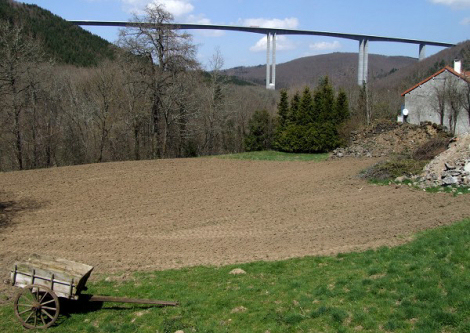
This viaduct has been chosen by abelard.org because … well just look at it:
twice piercing the sky, with its richly-coloured cables, as the motorway snakes across it and the Gorges of Sioule, then into the Augverne landscape. The nearby aire is basic, being mostly parking encircled by the access road. Go just cross the access road and drink in the view, while other travellers picnic.

Viaduct de Chavanon

some facts and figures on the Viaduc de Chavanon

  • Suspension bridge: monocable across A-pylon towers
  • Construction completed in 2000, after three years of work
  • Cost: 24.4 million €
  • Total length: 360 metres
  • Widest span: 300 metres
  • Angle of pylons: 20°
  • Height above the Chavanon valley: 100 metres
  • Deck width: 22 metres
    deck height: 3 metres
    deck construction: box made of a mixture of steel and cncrete
  • 61 vertical strands from 2 cables
    43 prestressed anchor ties embedded in the rock
  • Architect: Jean Muller
  • Material used:
    Concrete: 10,000 m3
    Steel: 2,530 tonnes
  • The only suspension viaduct/bridge in Europe where the central span is supported solely by the cables attached to the two A-shaped concrete pylons. The 30 m side spans and their cables give no support to the central span of the road deck.
  • The first suspension bridge built in France since the Tancarville and Aquitaine bridges, built over 30 years previously.
  • Road deck was built by the innovative and appropriately named Tarzan Method.
    This is a segmental construction using temporary cable-stays, with span-by-span in-situ casting on standard falsework (temporary shuttering used as a mould for the deck’s concrete structure). The deck is suspended like Tarzan as he swoops between trees on long rope-like vines.


viaduct de Sioule

The Sioule viaduct on the A89. Image credit: structurae.de
Image credit: structurae.de; photographer: Jacques Mossot

The Sioule viaduct is very close to motorway junction 26, Pontgibaud. From here, above 12 km (8 miles) along the D941 is Vulcania, the highly recommended educational theme park on volcanoes and geology.

Motorway sign forwarning of the gorges of Sioule
View to a (dead) volcano near the Vulcania theme park
Left: Motorway sign forewarning of the gorges of Sioule
Right: View to a (dead) volcano near the Vulcania theme park

some facts and figures on the Viaduc de Sioule

  • Cantilever bridge: hollow box, haunched
  • Construction completed in 2005
  • Opened in January 2006
  • Cost: 47, 386, 835 €
  • Total length: 990.5 metres
  • Widest span: 192 metres
  • Height of pylons: 135 metres
  • Height above the the Sioule valley: 150 metres
  • Deck width: 19 metres
  • Cable-stay length: 15.5 metres
  • Architect: Berdj Mikaelian
  • Material: concrete especially designed for this viaduct containing smoked silicon and CHRYSO®Fluid Optima 175. Concrete resistant to water while still fluid, and resistant to frost when set, qualities needed for the severe conditions during construction.
    • Concrete: 49,000 m3
    • Steel: 6,500 tonnes
    • 1,200 tonnes pre-stressed concrete
    • The gravel came from the Duron quarry and the sand from the plain of the Allier.

Les Pins and Le Lac aires

These two aires are virtually opposite each other, although there is no access between them. However, this does mean whether you are travelling east or west, you can stop at an excellent aire about 36 km from Clermont Ferrand.

going east - les Pins aire (and away from Clermont Ferrand)

the spacious, green Les Pins aire on the A89 autoroute, going east from Clermont Ferrand
The spacious Les Pins aire on the A89 autoroute, going east from Clermont Ferrand

Play area at Les Pins aire,on the A89 autorouteYou may have only left Clermont Ferrand 36 km (22 miles) beforehand, but this lovely, open and empty aire is well worth a visit. When abelard.org visited, at 11am in the peak summer season, the aire was very quiet.

Les Pins aire may not be one of the largest aires, but it is very substantial. It is also very green, with many trees (not just pines) providing welcome shade in the summer sun.

There is a smart, new-looking play area for children and, as so often, some ‘refreshing and cooling showers’.

A possibly unexpected sensation at this aire is that it is relatively cool, the result of being about 700 metres (about 2275 feet) above sea level. [Remember that each 1000 metres you go above sea level is equivalent to going back a month in weather terms.]

marker at abelard.org


going west - le Lac aire (and towards Clermont Ferrand)

view at Le Lac aire, A89 autoroute, going west 
      towards Clermont Ferrand
view at Le Lac aire, A89 autoroute, going west towards Clermont Ferrand

This aire has two, no, three parts. First there is the treed and grassy area with picnic tables, down the slope from the motorway. Then there is the lake, walled where there is access, and wooded where there is not. finally, up in the woods beside and beyond the lake, there is a walk - for fitness, and for education. There is a variety of trees and some are labelled with large wooden boards, with the tree’s name, as well as more picnic tables. [Note abelard.org’s photos were taken after an unexpected Spring snowfall.

Part of the fitness walk at Le Lac aire on the A89 autoroute.    A tree labelled on the fitness walk at Le Lac aire on the a89 autoroute.   Picnic table on the fitness walk at Le Lac aire.

aire de suchères

            The fallen column at Sechères aire, A89.            

Accessible as you travel west towards Clermont Ferrand, this aire has an extraordinary artwork, well worth walking up to and alongside.

But it is not all. There is a substantial play area and, concealed down the slope and amongst the screen of small trees, are wood-topped picnic tables and more places to walk.

  the 
            play area, with snow-topped wooded 'mountains' behind  
  picnic area amongst the birch trees, downhill from the motorway.  
  Above: the play area, with snow-topped wooded ‘mountains’ behind
Below: picnic area amongst the birch trees, downhill from the motorway


end notes

  1. aire: in this context, an area —
    aire de loisirs: recreation area;
    aire de pique-nique: picnic area;
    aire de repos: rest area;
    aire de services: services , motorway (GB) or freeway (US) service station.

  2. A sketch map of a proposed A89 motorway running to Lyon, with a short commentary/description in French is available here. The text translates as:

    Looking forward to a horizon of 2010-2015 - improving the link between Bordeaux and Lyon.
    marker at abelard.org From Libourne, a direct link is being studied in order to relieve the load on the Bordeaux ring road, while giving a direct access to the direction of Paris.
    marker at abelard.org Faced with the foreseen overload of the A20 at Brive (to which the A89 is grafted with a bypass north of Brive, as a un-tolled part of the A20) this section will have to be built.
    marker at abelard.org Finally, the State foresees the prolongation of the A89 from Balbigny to Tarare, then constructing a 2 by 2 lane motorway to Lyon. It is noted that more than five years of studies have been lost by the querying of the project by ministerial decisions. The new study ordered has come to the same conclusion as ... the previous one! That is to say the need for a motorway-standard link between Balbigny and Lyon. On the map, the evidence jumps to the eyes. It is abnormal that a Clermont-Lyon journey goes by way of ... St Etienne!

    Also in French, a short summary of the Senatorial discussions on extending the A89, with links to relevant documents.
on first arriving in France - driving motorway aires, introduction
travelling by rail to and within France Les Pyrénées, A64 Poey de Lascar, A64
aires on the A75 autoroute from clermont-ferrand to béziers Pic du Midi, A64 Dunes, A62
aires on the A89 autoroute from bordeaux to clermont-ferrand and beyond Hastingues, A64 Mas d’Agenais, A62
aires on the busy A7 autoroute from lyons to marseille Pech Loubat, A61 Garonne, A62
aires on the motorway to Spain - the A9 autoroute Port-Lauragais, A61 Catalan village, A9
three aires on the canal du midi, A61 Ayguesvives, A61 Tavel, A9
aires on the autoroute of two seas - the A62 Renneville, A61 Les Bréguières, A8
aires on the other autoroute of two seas - A64 and A61 Carcassonne, A61 Lozay, A10
from Lyon to Switzerland and Italy - motorway aires on the A42 and A40 in Poitou-Charentes: motorway aires on the A83

abstracts | briefings | information | headlines | loud music & hearing damage | children & television violence | what is memory, and intelligence? | about abelard

email abelard at abelard.org

© abelard, 2006, 17 july
v1.0

all rights reserved

the address for this document is http://www.abelard.org/france/motorway-aires12-a89.php


Aire de Correze Aire de la Loutre Sioule Viaduct Viaduc de Chavanon