france
new! Cathedrale Saint-Gatien at Tours 
 updated: Romanesque churches and cathedrals in south-west France updated: Romanesque churches and cathedrals in south-west France
the perpendicular or English style of cathedral 
the fire at the cathedral of Notre-Dame de Paris

cathedral giants - Amiens and Beauvais
Stone tracery in church and
cathedral construction 
stone in church and cathedral construction stained glass and cathedrals in Normandy 
fortified churches, mostly in Les Landes
cathedral labyrinths and mazes in France
using metal in gothic cathedral construction
Germans in France
cathedral destruction during the French revolution, subsidiary page to Germans in France

on first arriving in France - driving
France is not England
paying at the péage (toll station)

Transbordeur bridges in France and the world 2: focus on Portugalete, Chicago,
Rochefort-Martrou
Gustave Eiffel’s first work: the Eiffel passerelle, Bordeaux
a fifth bridge coming to Bordeaux: pont Chaban-Delmas, a new vertical lift bridge
France’s western isles: Ile de Ré
France’s western iles: Ile d’Oleron
Ile de France, Paris: in the context of Abelard and of French cathedrals
short biography of Pierre (Peter) Abelard
Marianne - a French national symbol, with French definitive stamps
la Belle Epoque
Grand Palais, Paris


Pic du Midi - observing stars clearly, A64
Carcassonne, A61: world heritage fortified city
Futuroscope
Vulcania
Space City, Toulouse
the French umbrella & Aurillac
50 years old:
Citroën DS
the Citroën 2CV:
a French motoring icon
the forest as seen by Francois Mauriac, and today
Les Landes, places and playtime
roundabout art of Les Landes
Hermès scarves

bastide towns
mardi gras! carnival in Basque country
country life in France: the poultry fair
what a hair cut! m & french pop/rock

Le Tour de France: cycling tactics
advertising
disclaimer
|
- introduction - île
de ré and île d’oleron
île
de ré
- • braking the summer traffic jams from 2017
- • climate • île
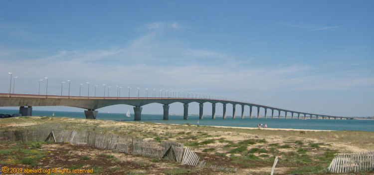
de ré bridge
• beaches • cycling
• agriculture
• bird watching
• salt
production/saliculture • lighthouses
• other
places to visit
• After
the storm Xanthia
- end
notes
-
île de ré and île d’oleron
On the western
edge of France, and facing into the Atlantic Ocean, these two
islands are remote from, yet close to mainland French society.
Both islands were part of the English empire of the 13th and 14th centuries. Both islands are now connected
to the mainland by modern, arching bridges. Both islands rely
on tourism and marine industries for the most part of their incomes.
Both are somewhat reminiscent of the British Channel Islands,
with sandy beaches, low road speed limits, little high street
commercial development, white or brightly painted cottages in
narrow-laned villages, and lots of sunshine.
But here the
similarities end. The Île de Ré, the smaller of these
two islands, is close to the major provincial town of La
Rochelle. Both before its viaduct was built (finished in 1998)
and now, the island was a favoured holiday
retreat for affluent Parisians. In summer, the island is even
nicknamed the 21st arrondissement of Paris. One such affluent
Parisian who has a holiday home there is former Prime Minister
(1997 to 2002), Lionel Jospin. Its less developed cousin, the
Île d’Oleron, has not yet received the same attention,
even though some may prefer its quieter roads and beaches.
Plenty of hotels, vacation homes and lots of camping opportunities
abound. the climate is usually mild and offers plenty of sunshine.
The locals are known for their friendly and laid back temperament.
île
de ré
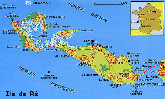
This
island is low-lying, its highest point at Peu-des-Aumonts being
a lofty 27 metres/29.5 yards, while the average height above sea-level
is 20 m/22 yards.
Île de Ré is 26 km/16 miles
long and
its width varies between 70 m/76 yards and 5 km/3
miles wide.
There is 100 km/62 miles of coast-line, half
of which is beaches, mostly to the south-west.
Its area
is about 85 km²/a bit over 21,000 acres, and approximately
a quarter the size of the Ile de France [the region surrounding
Paris].
Originally three small
islands, the spaces between them either silted up or were
filled by the extensive salt beds that are a major part of this
very flat, lowland island’s landscape. [Here is a
four-image animation of how the islets joined over the millennia.]
braking the summer traffic jams from 2017
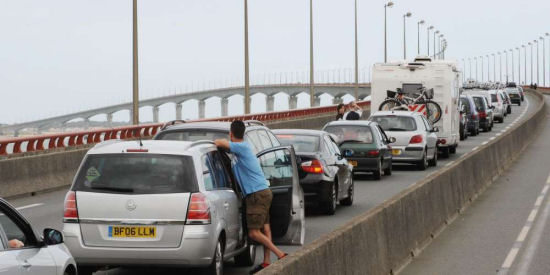 Traffic jam on the Ile de Ré bridge. Image: Xavier Léoty
- During the peak of the summer, 120,000 people come to the Île de Ré, with a peak traffic flow of around 1,200 vehicles per hour. This large traffic inevitably generates large traffic jams.Faced with this influx, the ilsland Council and the Département have taken measures to limit the number of cars on the island. The objective is to develop public transport within the island, and with the mainland.
Transfer stations have been created to prevent coaches from encroaching the town centres. The towns and villages can then be accessed by by electric shuttle buses. In total, five transfer stations between coaches and electric shuttles have been created :
- in Sablanceaux, Sainte-Marie, La Couarde, Saint-Clément-des-Baleines and Saint-Martin-de-Ré. The last has been operational since 3 July.
- The main objective of the € 250,000 project, financed by the transport portion of the ecotax, is to preserve the classified site of Saint-Martin-de-Ré.
- The plan, built with the backing of the Bâtiments de France (Buildings of France), also avoids the entry of coaches in the town centre thanks to the electric shuttles. Another measure, aimed directly at motorists, is a website called Respiré info trafic that also enables real-time monitoring of traffic conditions on the island. This project, with a total budget of 96 000 euros, aims to make traffic more fluid. Four cameras have been set up in the commune of Rivedoux, so go to the mobile site to watch the traffic conditions in real time.
seven cameras
In addition to these webcams, there are Bluetooth sensors. These calculate the speed of the vehicles from a point A to a point B in order to know the speed of traffic. Set up in partnership with the company Lacroix Neavia, this project is not yet complete. By the end of July, the island will have seven cameras. Pierre-Yves Courtine, project manager, is reassuring:
- "The idea is not to monitor people, but to track road traffic. "The image quality of webcams does not allow you to view license plates or identify passers-by."
In the long term, the data collected will help to anticipate the risks of traffic jams and to develop infrastructures for improving traffic conditions. By the autumn, three more sets of Bluetooth cameras and sensors will be placed on the La Rochelle bypass.
-
|

salt beds on the Île de Ré
There are ten communes [townships] on Île de Ré. The most
populated town is Sainte-Marie-de-Ré
(pop. 3,027), but Saint-Martin-de-Ré,
a small town rich in history, together with the nearby town of
La Flotte has 5,504 inhabitants, so making it the main urban focus
on the island. The smallest town is Loix (pop. 703).
Characteristically, the towns have narrow lanes lined by old, whitewashed cottages
and houses, colour often being provided by the ubiquitous hollyhocks.
Because of their narrowness, these lanes are often difficult to
negotiate by car - often only one car may pass, with tight corners
and parked vehicles providing further tricky obstacles to navigate.

whitewashed, sun-drenched street in Île de Ré
climate
Île de Ré has a mild climate, thanks to its coastal position
close to the warm Gulf Stream. The island has an average of 2,300
hours of sunshine a year, making it the third sunniest area in
France after South-eastern France and Corsica. Île de Ré
is sometimes called the “Atlantic Midi”. In the summer,
heat is mitigated by the proximity of the sea. In winter, the
temperature is fairly mild and snowfall unusual, though rain is
more frequent in winter and autumn. This is due to the low-lying
nature of the island.
There is a daily online metéo [weather forecast] service (in French, but pretty intuitive). This
link is to the forecast for Saint-Martin-de-Ré. |
|
In the rest of the Île de Ré, scattered over much of the more
western and northern areas, are 350 hectares of salt-beds, where
seawater is evaporated and the salt left behind collected for
sale. The points of sale may be a souvenir shop in one of the
island’s towns, one of the many of the stalls in the market
area near the Phare
des Baleines, or even a producer’s hut by the side of
the road. Here is sold local sea salt, salt flavoured with herbs
or spices for using when cooking meats or fish, as well as a wide
variety of salt pots and even slightly salted fudge [caramel].
In the past, salt was essential to the fishing industry in order to preserve fish (particularly cod), caught far out at
sea, until the boats returned to port.

Salt beds being worked

Sauniers at work
Before the advent of mechanised transport, salt harvested was transported
to depots for packing in paniers carried by donkeys. There were
many mosquitoes, midges and other hungry insects congregating
around the warm still water, so to protect the legs of the donkeys
from insect bites, they were clothed in culotte, trouser
leggings. Now that salt is transported by tractor and trailer,
or lorries, donkeys are no longer employed. However, donkeys are
still kept, dressed in culottes, to draw a cart, providing rides
for visitors.
It is possible to find stuffed toy donkeys, complete with brightly decorated trouser leggings, in some of
the gift shops near the Phare des Baleines.

Of course, along the coast are many small fishing ports, supplying
the plentiful seafood to be found in restaurants and cafés.
The marine industry also processes 10,000 tonnes of oysters annually.
lighthouses
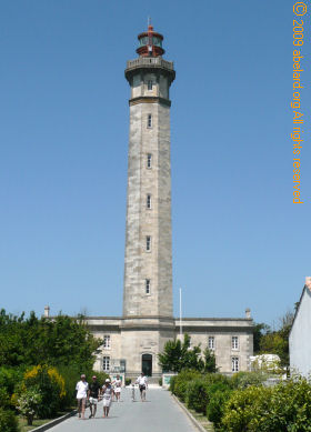 A centre of fishing, whaling and other maritime commerce, Île
de Ré has always needed warning and navigation signalling
for sailors nearing the island. [The lighthouses are marked on the map above, labelled as Phare.]
Thus, the main ports of the island, such as St. Martin de Ré
and la Flotte, have a lighthouse, and there is also the soaring
lighthouse at the north-west-most point, la Phare des Baleines,
together with its smaller predecessor. A centre of fishing, whaling and other maritime commerce, Île
de Ré has always needed warning and navigation signalling
for sailors nearing the island. [The lighthouses are marked on the map above, labelled as Phare.]
Thus, the main ports of the island, such as St. Martin de Ré
and la Flotte, have a lighthouse, and there is also the soaring
lighthouse at the north-west-most point, la Phare des Baleines,
together with its smaller predecessor.
The
57-metre high Lighthouse of Whales - Phare des Baleines - was built in 1854 [on the right] to replace the Old Lighthouse
[21 metres] built in 1682 by Vauban. The Phare des Baleines has
257 steps (the 61-metre Monument in London has 311 steps), which
visitors may climb to reach the top and the viewing balcony.
Both lighthouses are set within the Lighthouse domain, that includes
a whaling museum and a gift shop. (Note riding bicycles and picnics
are forbidden here, while dogs must be on a leash.)
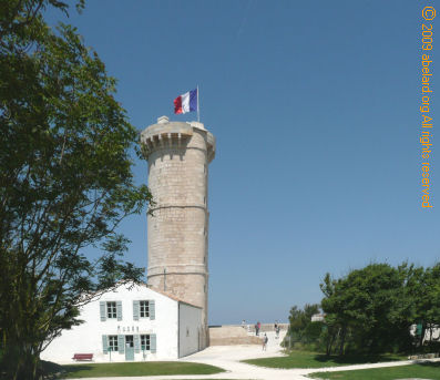
the lighthouse museum in front of the old lighthouse

at the approach to the phares [lighthouses] are many tourist shops and stalls,
often specialising in all manner of flavoured salt, salt accessories, model lighthouses,
postcards, stuffed toys and other tourist treats
other places to visit
Ars
- Ars en Ré
is located in the northern island of Ré (remember that
the Île de Ré was originally three separate islands.).
- There are many bike paths.
- The port, with 550
moorings, opens on Fier d’Ars bay to the north by a channel
through the marshes. From the port, you may explore the marshes
and its many migratory birds.
- The church was built in
the twelfth century and rebuilt in the fifteenth, its bell tower
still being used as a landmark for navigation.
- The former
windmills at la Boire milled cereals from the mainland.
St
Martin de Ré
- Many of this small town’s
historic buildings date from the 17th century.
- In
the 1620s, Cardinal Richelieu fortified the island as part of
the siege against nearby La Rochelle.
This included the Citadel [la Citadelle du Dépôt
des Forçats] at St Martin de Ré, but much of
the town’s defences were subsequently demolished to remove
potential threats to French royalty.
- In the 1670s, as
part of an overhaul of the island’s defences, St Martin
de Ré was enclosed by 12 kilometres of new, 8-metre high,
2-metre thick walls and embankments, protecting the town and the
island’s major port. Built by Vauban, these walls are now
part of a UNESCO world heritage classification.
- The citadelle
was later used as a prison [forçats] for convicts
on their way to French Guiana.

17th century map of St Martin
de Ré and its walls and fortifications
- Today, the town is a time capsule of old houses and the picturesque
port, enclosed by the massive walls pierced by a substantial gateway.
- There are plenty of cafés and restaurants by the
sea front and the port for relaxing before the expanse of Atlantic
dotted by fishing boats, tankers and private yachts.
- There is also a 18m lighthouse; painted with black and white bands, built in 1867.
After the storm Xanthia

Region affected by Storm Xanthia
8 April 2010:
Government officials announce black zones,
where housing will not be built, and existing housing will be
demolished (from July this year). Almost 1,400 land plots will
be returned to their natural state. 915 houses in Vendee and 595
houses in Charente-Maratimes are to be knocked down. This includes
many houses in the worst hit communes of La Faute-sur-Mer (674
houses, including 92 main homes) and l’Aiguillon-sur-Mer
(241 houses, including 25 main homes), as well as some houses
on the Ile de Ré.
Affected house-owners will receive
an average of 250,000 euro compensation on the building, but nothing
for the value of the land. Most house owners are not happy with
this announcement, especially after their communes had given building
permits for the houses now to be demolished.
2 April 2010:
Faute-sur-Mer comes back to life, with
one campsite, hardly touched by Xanthia, opening this weekend.
Another will take some months to be repaired and refurbished.
Elsewhere in the coastal regions of la Vendée, camp sites
and holiday homes are opening fore business as soon as the are
able, even if the locals are still waiting for summer weather.
10 March 2010:
Trying to return to normal after the
multiple funerals and a memorial service is difficult for l’Aiguillon-sur-Mer
and La Faute-sur-Mer. The children have gone back to school, with
trauma counsellors at l’Aiguillon-sur-Mer, but La Faute-sur-Mer
is now a ghost town - completely evacuated and the electricity
cut by the mayor.
At l’Aiguillon-sur-Mer, a house
has now collapsed after the ocean’s battering, and the Hotel
de Commerce, built in 1922 and a local landmark, is being demolished
today - its walls are no longer stable. Of course, the farmers
continue to have huge problems because their land is completely
salt-sodden, even the animal feed is affected, let alone this
seasons crops that had been growing in the now ruined fields.
There is now talk of shutting down the Municipal camping, completely
flooded and built within a floodable area.
3 March 2010:
The Île de Ré has returned
to its original arrangement of three small islands! As well as
the digue de Martray collapsing, separating the northern
part of the island, the part that contains Loix, the smallest
town on the island, has also been cut from the neighbouring parts
of the island. It was at Loix that the two deaths from the storm
occurred.
Despite being so low-lying and (as an island)
surrounded by the ocean, the Île de Ré and its inhabitants
weathered this extraordinary combination of storm and Spring tides
much better than their mainland neighbours. The locals believe
this is because, not only are they used to the wildness of the
sea and its storms and floods - “everyone has a pair of
waders”, but the Rétian mayors have ensured that
houses are not built on the more low-lying parts, unlike on the
mainland where houses have been widely built on floodable agricultural
land. There is also the small matter of, on hearing that there
was a Red Alert for the night to come,
Rétian mayors went out at 3 am waking up their villagers
and telling to move to safer places. The many drownings on the
mainland were mostly of elderly people living in bungalows, at
home and asleep in their beds.

Sea-wall breached at Saint-Martin-de-RéImage: AFP
1 March 2010:
On the night of 27th February, Xanthia blew through, with wind
speeds of 150kph, from the Azores, during a period of high Spring
tides [with a coefficient of about 115]. The result was high tides 1.50m above normal high
tides, and a ‘storm tide’, similar to a mini-tsunami.
This has caused the Île de Ré to be divided in two
near Ars-en-Ré, the digue de Martray being smashed
.

“On the Île de Ré, the
Martray sea wall has suffered the effects of the wind and the
sea.”
Image: sudouest.com
As
a result of this storm system, which affected the Atlantic coast
from La Rochelle to the Channel, at least 28 people drowned locally
(51 deaths overall), while throughout the Atlantic coast region,
one million homes were without electricity. Most of those that
died, lived in l’Aiguillon-sur-Mer and its close neighbour
La Faute-sur-Mer, on the coast just north of La Rochelle. The
village was submerged during the night when its protective, 200-year
old sea-wall collapsed under the battery of the wind and tide.
10-20% of visitor beds are now out of action, the campsites
have fared better. Most of the cycle tracks are still under water,
especially on the west of the island. Now to wait until the water
has gone, the damage assessed and the repair works can be done.
President Sarkosy has already released 3 million euro to help
the storm’s victims. |
end notes
- The inverted v-shaped
accent (or Chinese hat!) over the ‘I’
of Île, called a circumflex, is used in French to indicate a silent
‘s’. Thus the French word ‘Île’
is very closely equivalent to the English word ‘Isle’.
- La Rochelle
was a major port in the era of sail in the Atlantic
Ocean. It is still has many nautical connections, often
being the starting or ending point for ocean-going sailing
races. La Rochelle has a very picturesque port area,
now making much of it pedestrianised while providing
‘free’ bicycles.
In the past, La Rochelle
was controlled by the Dukes of Aquitaine who made it
a free port. Thus, when Eleanor of Aquitaine married
Henry Plantagenet of England, La Rochelle became English
until won back by Louis VIII in 1224.
During the Renaissance, La Rochelle adopted Protestant
ideas and from 1568 became a centre for the Hugenots,
declaring itself an independent reformed republic (as
had done Geneva). This led to continuing conflicts with
the Catholic central government. With the rule of Henry
IV (a Protestant who converted to Catholicism to become
King of France - “Paris is worth a mass”),
La Rochelle had some freedom and prosperity, but this
changed when Henry IV’s son Louis XIII became
king. Under the supervision of Cardinal Richelieu, La
Rochelle was besieged for fourteen months in the 1627-1628.
- As
a result of the popularity of island property, property
prices have risen to such an extent that young locals
are no longer able to buy a house, while local property
owners, often retirees, find that they have to sell
part of their property in order to pay annual local
taxes based on the current property value, rather than
on their income.
- Until
the Middle Ages, the Île de Ré was composed
of islands: Ré, the largest, corresponding to
the southern part of the actual island and the islets
of Ars and Loix (the islet of Portes became attached
to Ars islet from the first millennium). Gradually,
the channels between these islands were filled by naturally
deposited silt clay: the bri. The build-up
of these waterproof sediments, as well as the suitable
climatic conditions, give the idea of making marshes/salt
beds. To create them on a large scale, land has been
taken from low tide areas by building levées [levees or dykes] to keep out the sea at high tide.
The first salt beds were probably built from the
twelfth century by monks of the Abbey of Saint-Michel-en-l'Herm
(on the mainland to the north of La Rochelle), and
by the lords of Loix and Ars islets, commercial salt
extraction did not really take off until the fifteenth
century. In the nineteenth century, there were 1,550
acres of salt beds being worked (that is,18% of Île
de Ré’s area). At its peak, salt production
reached over 30,000 tonnes per year and provided much
of the island’s wealth.
From the 1850s, a long decline began with much of
the salt beds being abandoned. Reclaimed salt marshes
were lost again to the sea because the levees were
not maintained. By the start of the 1990s, the salt
miners, the sauniers, seemed doomed to disappear.
Fortunately, during the past ten years, an vigorous
policy to boost salt extraction has allowed young
farmers to settle and rehabilitate abandoned marsh,
thus perpetuating age-old skills and knowledge.
- Weather alerts
are made by Méteo
de France, the last local Red Alert being for Têmpete
Klaus in early 2009. Yellow or orange alerts occur
more frequently. The alerts are also given as part of
the news and the méteo on the television (at
13:00 and 20:00).
- Tidal
coefficient
Instead of looking at tide heights, the French use a
different system, based on percentages, known as the
tidal coefficient. A coefficient is a non-dimensional
way of expressing size, and is independent of the units
used. The Service
Hydrographique et Océanographique de la Marine [SHOM - web site in French], the French Hydrographic
office in Brest, produces a table of tidal coefficients
for the year.
The coefficient is calculated for the open sea. It is
the result of dividing the predicted tide height by
the average deep-water equinoctial tide. By convention,
the 100 coefficient is assigned to the daily tidal range
in medium-deep waters (about 6m) measured at the equinoxes
(March 21 , September 21).
Examples of tidal coefficients and how they translate
into tide sizes:
120 = a very big Spring tide
95 = a Spring tide (vive eau)
70 = an average tide
45 = a Neap tide (morte eau)
20 = a very small Neap tide
-

 |
The longest
day
20th Century Fox
Run Time: 178 minutes
DVD: 2003
ASIN: B0000DK4RJ
2003: £4.98 [amazon.co.uk] {advert}
ASIN: B000EHSVRS
2003: $17.49 [amazon.com]
Blue-Ray:
ASIN: B00158K0RY
2009: £17.99 [amazon.co.uk]
ASIN: B002COJEMW
2008: $20.49 [amazon.com] |
- From the
twelfth century with the construction of dykes, the
inhabitants of the Île de Ré - the Rétais
- took land from the sea in order to create salt beds
(called in French, salt marshes - marais salants).
Over the centuries, more than 1,500 hectares of salt
beds have been dug in clay sediments, the salt being
then one of the most important resources of the island
economy.

|