|
|
|
|
|
|
||
|
|
|
motorway aires,[1] introduction |
|
|
|
||
|
|
||
introduction Britain has free motorways. They usually have a service station every twenty or thirty miles, usually boring and probably rather seedy. In France, you pay through the nose for most motorways [autoroutes] (there are a few free motorways, around large cities and in Northern France) but there is one great joy and luxury that comes with this cost – an immense variety of aires. Government regulations demand that aires are placed at a maximum of 20 km intervals, so there is one without fail every twelve miles or so.
The aires range from small picnic areas with an emergency telephone, washup facilities and a few picnic tables/seats, to filling stations with a variety of services that can rival the worst of British motorway offerings, to super-colossal nirvanas with exhibition centres, expensive tourist teaser shops, incredible views and sometimes features of varying wonderment. A lot of the larger service-oriented aires include restaurants and motels. I shall start by assembling some ‘five-star’ aires, and then extend if or when I find time. There are quite often beautiful, mostly untouched, areas which form what might well be regarded as wildlife sanctuaries. Now I’ve told you about this, please don’t go trampling them and ripping up every wildflower in sight. To a great extent, the wild areas of aires survive because most visitors seem to pass them by unaware as they rush down the motorways and through life. Other than a couple of months each summer, known as “the Tourist Season“, these islands of interest are calm and not over-used. Many of the travellers stop for a quick bite and a leak before hurtling onward. All around the largest cities of France tend to be crowded, rather unpleasant motorway ring roads. Thus, as you approach or leave these conurbations, any aires are generally dusty, unpleasant, polluted, crowded, noisy and otherwise do not find a place on our best aires guide. So, if you are intending to spend time in these havens, and you are approaching or leaving the largest towns and cities, either stop before the countryside starts to smoke up, or expect to drive twenty or thirty miles away from the next city centre before the greatest marvels of airesdom become available.
Of course, before you do any long journey you should check your tyre pressures. If you haven’t, or you want to check again, at the very start or end of autoroutes or near toll barriers [at the gare de péage], you can sometimes find free tyre inflation points, mostly sponsored by the major French tyre company, Michélin, and often manned by a very jolly Michélin man. [2] In this section, I intend
to tell you mainly about some of the big feature aires, mostly
constructed by ASF. Some of them have a restaurant
or other facilities, such aires also are often large enough to
include quieter areas (there is, of course, the thunder of the
motorway race-track never very far away). These are well worth
taking some time out of your journey. Being eccentric, I am capable
of making a special trip with no other objective than to visit
one of these wonders. the french autoroute network
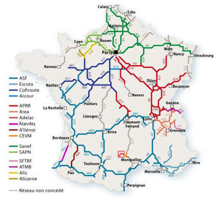
There are various private companies (concessionaires) that run the motorway systems, including some bridges and tunnels that convey motorways, in France. From the links below, you can reach maps, route calculators, toll charges, traffic information, webcams for various autoroutes. Some maps include access to details about aires. However, beware: these rich companies are enamoured of flash-coded pages, which are neither easy to navigate nor to control, although at times very clever or even pretty. [The French part of the A14 and the Paris-Normandy SAPN network are run by Sanef, part of the Spanish group Abertis. ASF and Cofiroute belong to Vinci, while Eiffage controls APRR (Paris-Rhin-Rhône).]
paying at the péage (toll station)Most French motorways require payment from the user. There are two main ways that this payment is demanded.
As you enter the paid part of an autoroute, you pass a booth where, usually, a toll ticket pops out at you at window level. As when paying (see below), you need to drive close to the kerb so you can actually reach and take the ticket.
The first thing to do on nearing a peage with several do-it-yourself payment point is to decide which one to use. It is useful to know that lorries will tend to use the booth on the right (to the inside of the carriageway). Next, generally do not chose a column with only a big orange T indicating télépeage, unless you are equipped for using those booths. Sometimes the T-marked columns are dual purpose and can be used to pay with coins. Go for the columns with the large green arrow. Péages can be small, with two or so payment gates, or large with an array of say twenty gates marching across a very busy motorway. One such is on the A63 motorway [photo above]. This motorway serves the huge heavy goods traffic between Spain and Portugal and the rest of Europe, as well as many holiday makers to the Spanish peninsula. Widening and modernising this péage has almost finished [September 2011]. During the summer, these large péages have extra autoroute employees, armed with a big satchel of change, who come to the aid of travellers dumbfounded by péages that often reject their coins, or who just can’t reach the bin or the receipt button. A smaller péage will have one (usually) manned ticket booth, and one or more self-service booths with a plastic basket into which to throw your coins. The manned ticket booth, or booths, will be to the right and will tend attract the lorry traffic.
When approaching the péage booth or the coin basket, take your time and move carefully. It is important to drive so as to align your vehicle as close to the kerb as possible, as well as stopping so your open window is next to the coin basket and slots for tickets and cards. As like as not, if you go too far forward, some helpful Frog will close up behind you, making it impossible to reverse back to the correct position. When correctly positioned, you will be able to take actions such as pressing buttons, inserting and removing a credit card, taking a recipt or change without, you hope, having to undo your seat belt and get out of your seat. Péage cash payment points have evolved over the years, mainly to become ever smaller and less convenient. In the photo above on the left, is one of the original change baskets that have plenty of space and the opportunity of watching the money dropping down like the balls in a pachinko machine. Below is a progression of the shrinking coin basket, though the labelling does become a bit more user-friendly.
If you are paying with a credit card, you need to make sure that the toll ticket and card are put in the right way up and pointing in the correct direction. Both credit cards and tickets have an arrow indicating the direction of insertion. You will also need to insert the toll ticket first. Should you want a receipt, you press or touch the appropriate button.
When your payment has been accepted, the big red light in front of you changes to green and the barrier rises. Bonne voyage and safe driving.
on toll chargesToll charges are now available at the autoroutes association website (in English).
Every season, tolls on French motorways are revised, and continue to climb. On average, the increase is about 2%. In 2021, the average increase in toll rates of 0.44% (on 1 February this year, rates were increased by between 0.30 and 0.65% depending on the route). The actual increase depends on the operator’s network. Toll prices are reassessed by the State every year based on a calculation which takes inflation into account. This is an increase between 70% and 90% of the rate of inflation. To this are added economic imperatives related to highway maintenance. This maintenance is the responsibility of the 18 companies that share the management of the motorway network in France. The money raised by tolls is distributed as follows:
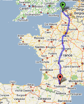
pre-route planning with GoogleMapsGoogleMaps has recently upgraded their map-searching facilities to include a cunning and useful ‘tool’ to help with the initial planning. [Note that GoogleMaps does not provide fuel usage or speed camera information.] And what can you now do with GoogleMaps that is so notable? Immediately underneath the Search box, first click on the Get directions link. The Search box splits into two. Next set the Start address, for example to Calais France, and set the End address to, say, Toulouse. Google calculates the following route between these two places:
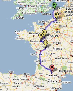
This route is 964 km, taking about 8 hours 47 mins to drive, according to Google. But then it might be nice to take a few diversions and visit a few cathedrals on the way. So, with the mouse, pick up and replace the blue line so it goes through some cathedral towns, say Amiens, Le Mans, Angers, Poitiers. Below is the resulting perigrination of 1,301 km, which takes about 12 hours 5 mins:
Trying alternative routes, with distance and time information being calculated on the fly, is very useful for initial planning. Then, once you have decided the overall route, it is better to use Mappy or Map24 which will give you distances in miles if you wish, as well as fuel and tolls costings, as well as speed camera positions. [There is a Google page with information on this new facility.] 19.04.2010 links to French motorway company web sites
|
new! Cathedrale Saint-Gatien at Tours
the perpendicular or English style of cathedral the fire at the cathedral of Notre-Dame de Paris Stone tracery in church and
cathedral construction stained glass and cathedrals in Normandy fortified churches, mostly in Les Landes cathedral labyrinths and mazes in France Germans in France on first arriving in France - driving
Transbordeur bridges in France and the world 2: focus on Portugalete, Chicago,
Rochefort-Martrou France’s western isles: Ile de Ré Ile de France, Paris: in the context of Abelard and of French cathedrals Marianne - a French national symbol, with French definitive stamps la Belle Epoque
Pic du Midi - observing stars clearly, A64 Futuroscope the French umbrella & Aurillac 50 years old:
Citroën DS the forest as seen by Francois Mauriac, and today bastide towns what a hair cut! m & french pop/rock
|
| abstracts | briefings | information | headlines | loud music & hearing damage | children & television violence | what is memory, and intelligence? | about abelard |
email abelard at abelard.org © abelard, 2004, 23 august the address for this document is https://www.abelard.org/france/motorway-aires1.php |