


|
|
|
|
|
|||
| site map | |
|
|
|
|
||
motorway aires: 20 |
|
|||
 |
|
|||
|
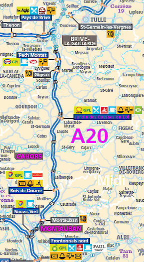
Motorway aires are designed to provide a suitable environment for relaxing, refreshing and recovering during the long, hard journeys. As well as facilities of often dubious nature, picnic tables and seats, a telephone kiosk, there are often optional extras such as a play area or a display related to some local interest or event. the A20 autorouteThe A20 is the first complete north-south route which goes through the centre of France. ( The second is the soon to be completed A75.) The A20 passes through regions of Centre, Limousin, Midi-Pyrénées. It was was proposed to reduce the travel time along the nearby trunk road, RN20. The A20 starts in the north at Vierzon in Cher, not far from the glorious cathedral city of Bourges, and finishes in the south at Montauban in Tarn-et-Garonne. There are further sections, between Orleans and Vierzon (A71) and Montauban-Toulouse (A62), that could be renamed the A20 in the not too distant future. Here we shall concentrate on the southern, tolled, section of the A20, from Brive-la-Gaillarde to Montauban (154 km, just under 100 miles), leaving the northern free section for the future. |
||
aire: Jardin des Causses du LotThis beautifully designed and appointed aire, between J56 and J57, is on the east side of the motorway but accessible in both directions. The Jardin des Causses du Lot aire is designed to give a real experience of the Lot countryside, while limiting the motorway functions, such as fuel and parking to the rear of a large, airy, modern building. With its wide, overhanging roofs and glassed walls, this building provides a feeling of coolness and shade after the baking Lot sunshine outside. The result is a relaxing yet modern ambiance, which gives a real contrast to the harshness of the nearby motorway. The terraced gardens and lakeside walk, together with the adventure of the observation point, add to make an aire well worth a visit. This is the only really interesting aire on this section of the A20. It is, conveniently, about half way between Brive-la-Gaillarde and Montauban.
The satellite image below gives no sense of how this aire is placed - on the heights of undulating landscape, so that in one direction the functional services are, at least, partially hidden in a fold of the hills, while in another the verdant, wooded and agricultural scenery is spread before you.
Walking through the main building, past the gift shop and cafeteria, you come out to a wide balcony overlooking a series of terraces. The balcony overlooking the terraces is wide enough to provide a comfortable and shaded eating area.
The terraces lead down to a lake (Lake Bhutan) and give views over Lot’s landscape. They are planted with mulberry trees, fig trees, cypresses and irises, emblematic of Lot’s position as an entrance to the region of Midi-Pyrenees and the South.
From the aire building, in the opposite direction to the terraces is a path leading to an observation tower (a mirador in French) which provides panoramic views, even to the foothills of the Central Massif in the north. There are at least two gates where you can leave the aire and walk in the neighbouring countryside, or visitors on foot may enter the aire [marked on satellite image map above]. The exterior of this aire was designed by Bruno Mader, architect, in association with Pascale Hannetel, landscape architect, and Pierre Verger, set designer. Cahors
A diversion into the town of Cahors is worthwhile, so you can gawp at a great wonder of European mediaeval architecture - a fortified bridge.
|
|||
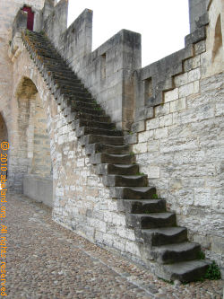
Built in the days of the 100 Years War, the Valentré bridge is a spectacular example of French military architecture of that period, and one of the finest fortified medieval bridges still standing. Designed to defend the city against attacks from the south, in the end neither the British nor Henry IV attacked from this direction. Building of the bridge started in 1308 and was finished seventy years later.
The contract for the building was given by the town Consuls to a local mason, proud at last to become a Master Mason.
Cahors is also known for its Appellation d’origine contrôlée (AOC) red wine. it is often tannic when young, and consider similar to robust Bordeaux wines.
MontaubanThe prefectural capital of Tarn and Garonne, Montauban is nicknamed “City of Ingres”, after the great nineteenth century painter, Jean-Auguste-Dominique Ingres, who was born here. There is an Ingres Museum in the town with 4,000 drawings by the artist. It is installed in the former bishop’s palace. Founded in 1144 by the Count of Toulouse, like many small towns in the south-west, Mountauban is considered as one of the first bastides, or fortified towns. As such, it meets certain criteria: all streets intersecting at right angles and a large central square. The old centre is very homogeneous, with no modern building breaking the harmony of red brick facades mostly built in the seventeenth and eighteenth centuries. Although many people know of the siege of La Rochelle, where Huguenot Protestants held out against their forcible conversion to Catholicism, orchestrated by Cardinal Richelieu, not many know that Montauban was similarly besieged. It was the last Calvinist safe refuge to fall to the king of France and its cardinal, to cries of “Vive le roi, vive le cardinal” - “Long live the king, long live the cardinal” - as the town welcomed in the king and his chief minister.
The marvellous main square of Montauban has buildings in shades of red and pink that glow in the southern sunlight. This square in the centre of Montauban is still reminiscent of the original central square of the bastide town, though much larger and grander, with arched arcades at the base of the buildings that provide sheltered and shaded areas for shops, stalls and cafés. In the Middle Ages, the merchant guilds met under the arcade arches, over which hung the symbols of their trades - clogs, wheat sheaf, cloth. Justice was meted out in the square and it was not until the Revolution that the pillory was demolished, to be replaced by a cross. The medieval facades of wood and cob were destroyed in two fires in the 17th century, but it was not until a hundred years later that the rebuilding was completed. The architects reproduced the original arcades, topped by different facades according to the tastes of their owners.
A corner of the Place Nationale - National Square. Cars drive through the corner arch to enter the surrounds of the square.
The sundial in the Place Nationale, erected in 1808, to commemorate a visit by Napoleon I. The sundial’s motto reads, “UNA TIBI”, which translates as “There will be one for you”. The motto continues, “May it be as late as possible”.
|
|||
| abstracts | briefings | information | headlines | loud music & hearing damage | children & television violence | what is memory, and intelligence? | about abelard |
© abelard, 2010, 21 april the address for this document is https://www.abelard.org/france/motorway-aires20-a20.php |


![View from the observation tower [mirador]](autoroute/a20/jardins4.jpg "View from the observation tower [<em>mirador</em>]")


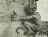 When
restoration work was done in 1879, a small model
of the devil stealing a stone was put high on the
northwest corner of the central tower, which you
can see if you look carefully.
When
restoration work was done in 1879, a small model
of the devil stealing a stone was put high on the
northwest corner of the central tower, which you
can see if you look carefully.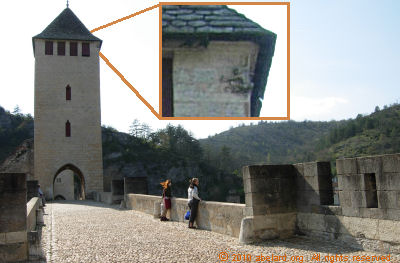
 Cahors
may be the capital of the
Cahors
may be the capital of the  In
Occitan (the language of
In
Occitan (the language of 


