france
new! Cathedrale Saint-Gatien at Tours 
 updated: Romanesque churches and cathedrals in south-west France updated: Romanesque churches and cathedrals in south-west France
the perpendicular or English style of cathedral 
the fire at the cathedral of Notre-Dame de Paris

cathedral giants - Amiens and Beauvais
Stone tracery in church and
cathedral construction 
stone in church and cathedral construction stained glass and cathedrals in Normandy 
fortified churches, mostly in Les Landes
cathedral labyrinths and mazes in France
using metal in gothic cathedral construction
Germans in France
cathedral destruction during the French revolution, subsidiary page to Germans in France

on first arriving in France - driving
France is not England
paying at the péage (toll station)

Transbordeur bridges in France and the world 2: focus on Portugalete, Chicago,
Rochefort-Martrou
Gustave Eiffel’s first work: the Eiffel passerelle, Bordeaux
a fifth bridge coming to Bordeaux: pont Chaban-Delmas, a new vertical lift bridge
France’s western isles: Ile de Ré
France’s western iles: Ile d’Oleron
Ile de France, Paris: in the context of Abelard and of French cathedrals
short biography of Pierre (Peter) Abelard
Marianne - a French national symbol, with French definitive stamps
la Belle Epoque
Grand Palais, Paris


Pic du Midi - observing stars clearly, A64
Carcassonne, A61: world heritage fortified city
Futuroscope
Vulcania
Space City, Toulouse
the French umbrella & Aurillac
50 years old:
Citroën DS
the Citroën 2CV:
a French motoring icon
the forest as seen by Francois Mauriac, and today
Les Landes, places and playtime
roundabout art of Les Landes
Hermès scarves

bastide towns
mardi gras! carnival in Basque country
country life in France: the poultry fair
what a hair cut! m & french pop/rock

Le Tour de France: cycling tactics
| Motorway aires
are designed to provide a suitable environment for relaxing, refreshing
and recovering during the long, hard journeys. As well as facilities
of often dubious nature, picnic tables and seats, a telephone
kiosk, there are often optional extras such as a play area or
a display related to some local interest or event. 
Tavel
nord aire, A9 and its sundials 
From the north, showing the scale of
the monumental Tavel sundial.
Note the circular illustration
of the zodiac on the ground. [Photo composite]

From the south, showing different
parts of this multiple sundial structure The
busy A9 autoroute between Orange and Nimes leads to the western
stretch of the French Mediterranean coast. The southbound
Tavel aire is dominated, not by the service station, shop
and café clustered at the base of a small hill, but by
the structure visible from the motorway : the asymmetric, futuristic
yet mathematical and educational monumental sculpture - an enormous
set of sundials, the Nef Solaire : the Solar Ship or
Nave. This edifice is like huge sailing ship, or a cavernous cathedral.
It is built of four white concrete sail-like structures, butted
one against another with the highest point 17 metres high. In
all there are five sundials : three vertical ones on three of
the four ‘sails’, and two horizontal ones (on the
ground) for morning and afternoon. ![Morning horizontal sundial [taken in the afternoon, so the shadow does not mark the actual solar time] on the Nef Solaire, Tavel](autoroute/tavel/tavel2b.jpg "Morning horizontal sundial [taken in the afternoon, so the shadow does not mark the actual solar time] on the Nef Solaire, Tavel")
Morning horizontal sundial
[taken
in the afternoon, so the shadow does not mark the actual solar
time]
As well as the five dials, there are two gnomons
[that’s the stick bit, also known as a style] which throw
shadows on the various sundials. At any time of day, at least
two of the dials are active - one horizontal and one vertical. Built
in 1993, the sundials are surrounded by Mediterranean garrigue
planting - olives, pines and poplars, together with strong-smelling
rosemary and thyme. The main originators were sculptor Odile Mir,
gnomonist Denis Savoie, and engineer Robert
Queudot. ![The afternoon horizontal sundial [afternoon gnomon on the left], part of the Nef Solaire, Tavel](autoroute/tavel/tavel2a.jpg "The afternoon horizontal sundial [afternoon gnomon on the left], part of the Nef Solaire, Tavel")
The afternoon horizontal sundial.
This detail shows the shadow from the afternoon gnomon
[on the left] marking just after 16.00 solar time.
Note
the shadow time is marked on both the ground and the sail.
This time would need to be converted
to match the equivalent clock time.
The enormous
sundials are set to Universal Time [UT], which is the same as
Greenwich Mean Time [GMT]. However, the Tavel sundial is not on
the same longitude as Greenwich. The
solar time at Tavel is GMT plus 18 minutes
45 seconds.
[Click for detailed
information on converting the solar time as indicated by these
sundials, into clock time as shown on a watch.] 

Mounted on knee-high blocks around the sundial are information
plaques, some of which give instructions on how to correct the
time provided by the sundials into clock (civil) time.
Unfortunately, the plaques are only in French. There
are also other panels that describe the history of different sundials
since early times. Here are translations of the French text for
those panels:
 | Gnomon
This primitive sundial functions with an obelisque or stick planted
vertically in the ground, the shadow of which marks the time of
day. The gnomon was used from earliest antiquity by practically
all ancient peoples. Despite its imprecision, it served [...]
to make astronomic measurements. |  | Scaphé
- sphère creuse - hémisphère
This type of sundial dates from the 3rd century BC, it was made
by the Greeks and Romans. The scaphé was most often in
a hemispherical or conical form. The time between sunrise and
sunset was divided into 12 equal parts, whatever the season. This
resulted in a variable length or an hour, for France a hour would
be 40 minutes in winter and 80 minutes in summer. |
 | Tall
sundial - pole sundial
During the Renaissance there
appeared portable
sundials of several types - the shepherd’s watch, the
astronomer’s ring. The orientation of the pole sundial depends
on the the position of the Sun through the day. |
 | Analemmatic
sundial
First described by Francis Vauzelard in
1640, the Analemmatic sundial has an elliptic shape. It functions
with a vertical style, which is moved according to the month.
Later, it was simplified and extended to work in with different
longitudes (different orientations) and latitudes (different inclinations). |

| Polar style sundial
Towards the
18th century, there appeared a flat sundial equipped with an inclined
style that pointed towards the Pole star. Already known to the
Arabs for at least two centuries, this arrangement brought and
important improvement - the indication of the hours remained the
same all year round, unlike for previous sundials. This type of
sundial had several variations and could include curves to indicate
the solstices and equinoxes. |  | Canonical
dial
This sundial appeared on church facades during
the 18th century. It was in the form of a circle (or more often
a semi-circle) divided into six, eight or twelve equal sections.
There were no numbers. At the centre of the dial, a horizontal
stick threw a shadow which showed the prayer hours.
[Sundials
bridged the gap between art science, and varied considerably.
A dial may be labelled, for example, with Prime,Tierce, Sext,
None, Vespers.] |  | Two-wire
sundial
Invented in 1922 by a German mathematician,
Hugo Michnik, the two-wire sundial is rather special. The hour
is indicated by the intersection of the shadows of two wires,
set at different heights and which are perpendicular to one another.
This makes possible having a constant interval of 15° between
each hour line. | There are examples of other
types of sundial included in the outdoor displays at the Cité
de l’espace - Space City - at Toulouse. 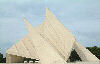
As
well as being a sundial, the structure at Tavel aire includes
a ring of illustrations showing how the signs of the zodiac relate
to constellations. The Earth revolves around the Sun in
just over 365 days. From here on Earth, it appears that that the
Sun moves relative to the stars. The constellations amongst which
the Sun appears to traverse successively are the constellations
of the zodiac. There are twelve constellations, decided because
the related stars, when joined up like dots, apparently make outlines
that have some relation to constellation’s name. Thus, at
the Spring Equinox (20 March), the Sun appears to traverse before
the constellation of Pisces; at the Summer Solstice (21 June)
before the constellation of Gemini, and so on. 
Zodiac constellation - Gemini
How
to reach the Tavel nord motorway aire
The
Tavel North aire reviewed on this page is accessible from both
directions of the A9 autoroute, from the northbound direction
by a connecting road tunnel between the two sides. The aire on
the southbound side of the autoroute also has fuel, shop, a café.
[abelard.org has not yet visited Tavel Sud].
The Tavel aires are in Département 84 - Vaucluse.
Time,
the sun and clocks Sun time is different
from clock time.
For a sundial at any place on the Earth,
noon [12 midday, 12 p.m.] is when the sun passes the local meridian
line [line of longitude]. This is when the sun is highest in the
sky for that place and that day of the year. It is also when shadows
are at their shortest. But the amount of clock time between that
noon and the next noon will probably differ. A clock or
a watch marks the same amount of time, 24 hours, passing between
one noon and the next, whatever the time of year. Clocks and watches
show a mean or average time that ignores the real slight differences
in day length through the year, and also ignores the fact that
a day is not exactly 24 hours long, nor a year exactly 365 days
long. (A year is, in fact, 365 ¼ days long.) Thus, solar
time can be faster or slower than clock time. Small differences
between the length of day for sundial [solar] time and clock/mean
time gradually compound to become larger differences between the
two types of time at some periods of the year.
Varying
day lengths Day lengths
vary for three main reasons: -
Obliquity:
the Earth’s axis of rotation is tilted [inclined] as it
circles the Sun, so the Equator is not parallel to the
orbit of the Earth around the Sun. The angle of this tilt is called
the angle of obliquity. This angle measures 23°26'.
This means that the plane of the Earth’s equator is inclined
relative to the plane of the Earth’s orbit around the Sun.
Because of the inclination, the Sun is at its highest point
(overhead) in the sky [at the time known as noon] at different
latitudes, at different times of the year. The higher the Sun
reaches, the longer that day lasts. All this also means that the
length of daylight varies according to the latitude of the observer.

The inclination of the Earth results in
the seasons. In the Northern hemisphere, the Sun is high at noon
in June (summer) and low on the horizon in December (winter).
This is reversed in the Southern hemisphere, where the Sun is
high at noon in December (summer)and low on the horizon in June
(winter). At the Equator, the length of day hardly varies throughout
the year. Because of this, the length of daylight
time differs during the year, being shorter in winter when
the sun is low and so above the horizon for a smaller part of
a day, and longer in summer when the sun is above the horizon
for more of a day. 
- Eccentricity:
the Earth’s orbit around the Sun not a circle, but an ellipse.
Thus the apparent motion of the Sun varies throughout the year,
with the Sun appearing to move fastest when the Earth is closest
to the Sun in winter, and slower in summer when it is further
away. [The sun is closest to Earth on 3rd January - 91.3 million
miles/147.5 million km, this is the perihelion; the sun is furthest
away on 4th July - 94.4 million miles/152 million km, this is
the aphelion.] The Sun’s gravity pulls on the Earth harder
when the Earth is closer to it. This pull increases the Earth’s
speed by about 20 miles per hour. To put this in context, The
Earth orbits the Sun at an average speed of 18 ½ miles
per second, or 67,000 miles per hour. [Detailed
explication: 2-page .pdf.]
The longest solar
day is 19th December, it is 24 hours, 28 seconds long. The shortest
day is 14th September and is 23 hours, 59 minutes and 38 seconds
long. These two differences between solar time and
clock time are corrected by using the
Equation of Time, or EOT. [The EOT is usually presented as
a table, or as a graph, of calculated
differences between solar and clock time.]
The following
diagram is a graphical presentation of how solar time differs
from clock (mean) time during a year, with the components caused
by eccentricity (the Earth’s eliptic orbit) and obliquity
(the tilt of the Earth). 
-
Differences because of your longitude
A
further difference in time results from the Sun passing at its
highest point at different moments consecutively as it goes round
the Earth. The Sun moves from East to West in the Northern Hemisphere,
thus noon for someone in London, England actually occurs before
someone in Bristol, although both cities are in the same country
and the same time zone. Bristol is 2 ° 35' west of Greenwich,
and so noon at Bristol is a little over 10 minutes later than
noon at Greenwich [15° longitude = 1 hour; 1° longitude
= 4 minutes time].
Longitudes are imaginary half-circles
running around the world, starting at the North Pole and ending
at the South Pole. Thus London and
Bristol are at different longitudes, although they are at a roughly
similar latitude (distance from the Equator). The Sun passes over
longitudes consecutively as the Earth completes its daily rotation
on its axis.
In the days before clocks were able
run accurately, public sundials, like those to be seen on church
facades, were used to reset the clocks.
Before
the Industrial Revolution in Britain, there was no particular
need for clocks in different towns to show exactly the same time.
Each town ran on its own time, based on the town’s longitude
- this determines when noon [the Sun’s highest point in
the sky during a day] occurs at any location.
The
introduction of railway transport stretching from one end of Britain
to the other, and related communications brought by the telegraph,
changed that. It became necessary for all railway stations, and
so all towns, to run on the same time, which was first known as
Railway Time, first introduced in 1845. Thus
towns gradually came to use a standardised time - Greenwich
Mean Time [GMT] , based on the longitude that passes
through Greenwich, south London. GMT is now called Universal
Time [UT]. Other, lesser reasons for variation
in the length of a day are: - The earth spins at an
irregular rate around its axis of rotation.
- The
earth ‘wobbles’ on its axis.[6]
Clock
time - Mean time A clock measures a day assumed
to be the same length - 24 hours - every day of the year, despite
day lengths varying through out the year [see varying
days lengths]. This is Mean Time, where all days are taken
to last exactly 24 hours.
Summer
time When Summer Time - Daylight Saving Time - adds
an hour to the standard time, there are three reasons why a watch
or clock does not show the same time as that shown by almost any
sundial [these differences are described in more detail in other
sections of this web page]: - By assuming the days
are all the same length. Because of the effect of the Earth’s
inclination (tilt) and its elliptical
orbit, a day’s length can vary by up to about 15 minutes.
The Equation of Time corrects
for these differences.
- By
not being on the local standard meridian.
The Greenwich Meridian running through South London at Greenwich
is probably the most famous, but each time zone has its meridian
on which the local time is based. The sundials at the Tavel Aire
are marked according to Universal Time, based on the Standard
Meridian [or longitude] , which is the Greenwich Meridian at 0°.
However, France uses Central European Time, based of the
meridian of 15°E that passes through Prague. Therefore for
these sundials, an hour has to be added to convert to Central
European Time.
(There is a 4 minute variation for every
1° you are east or west of your designated standard meridian.
Because Clock Time is an average or mean
time, no allowance is made for this smaller variation from the
actual time at the standard meridian.)
-
Because of the hour added as required for Summer Time/Daylight
Saving, there can be a further 60 minutes difference.
Telling
the time using a sundial On a sundial, a
stick is called a gnomon casts its shadow on a marked dial. Where
the shadow falls on the dial gives the solar time for that particular
latitude and longitude. The length of the shadow the gnomon
varies throughout the year, being long in winter and short in
summer. A sundial marked with curves, called diurnal arcs, can
indicate the seasons, as well as the time (shown by the position
of the shadow).
To
convert sundial time to clock [civil/legal] time
- During Summer/Daylight Saving Time, add one hour to the sundial
time.
-
- Add a correction for not
being on the same longitude as the Standard Meridian for the local
time zone. In the case of the sundials at the Tavel Aire, you
add 18 minutes 48 seconds. The
standard meridian for France being the Greenwich Meridian
- 0° longitude.

Table of corrections
for the Nef Solaire sundials at Tavel, A9
[based on the
Equation of Time] | | January | May | October |
| 1st - 2nd | 45
mins | 1st - 28th | 38
min | 1st - 2nd | 31
min | | 3rd - 4th | 46
min | 29th - 31st | 39
min | 3rd - 5th | 30
min | | 5th - 7th |
47 min | June | 6th
- 9th | 29 min | | 8th
- 9th | 48 min | 1st
- 4th | 39 min | 10th
- 12th | 28 min | | 10th
-12th | 49 min | 5th
- 9th | 40 min |
13th - 17th | 27 min |
| 13th - 14th | 50 min | 10th
- 14th | 41 min | 18th
- 23rd | 26 min | | 15th
- 17th | 51 min | 15th
- 19th | 42 min | 24th
- 31st | 25 min | | 18th
- 21st | 52 min | 20th
- 23rd | 43 min | November |
| 22nd - 25th | 53
min | 24th - 28th | 44
min | 1st - 14th | 25
min | | 26th - 30th | 54
min | 29th - 30th | 45
min | 15th - 18th | 26
min | | 31st | 55
min | July | 19th
- 22nd | 27 min | | February | 1st
- 3rd | 45 min | 23th
- 26th | 28 min | | 1st
- 23rd | 55 min | 4th
- 9th | 46 min | 27th
- 29th | 29 min | | 23rd
- 28th | 54 min | 10th
- 19th | 47 min | 30th | 30
min | | March | 20th
- 31st | 48 min | December |
| 1st | 54
min | August | 1st | 30
min | | 2nd - 6th | 53
min | 1st | 48
min | 2nd - 4th | 31
min | | 7th - 10th | 52
min | 2nd - 10th | 47
min | 5th - 6th | 32
min | | 11th -13th | 51
min | 11th - 15th | 46
min | 7th - 8th | 33
min | | 14th - 17th | 50
min | 16th - 20th | 45
min | 9th - 11th | 34
min | | 18th - 20th | 49
min | 21st - 24th | 44
min | 12th- 13th | 35
min | | 21st - 24th | 48
min | 25th - 27th | 43
min | 14th - 15th | 36
min | | 25th - 27th | 47
min | 28th - 31st | 42
min | 16th - 17th | 37
min | | 28th - 30th | 46
min | September | 18th
- 19th | 38 min | | 31st | 45
min | 1st - 3rd | 41
min | 20th - 21st | 39
min | | April | 4th
- 6th | 40 min | 21st
- 23rd | 40 min | | 1st
- 3rd | 43 min | 7th
- 9th | 39 min | 24th
- 25th | 41 min | | 4th
- 6th | 44 min | 10th
- 11th | 38 min | 26th
- 27th | 42 min | | 7th
- 10th | 43 min | 12th
- 14th | 37 min | 28th
- 29th | 43 min | | 11th
- 14th | 42 min | 15th
- 17th | 36 min | 30th
- 31st | 44 min | | 15th
- 18th | 41 min | 18th
- 20th | 35 min | | |
| 19th - 23rd | 40
min | 21st - 23rd | 34
min | | |
| 24th - 29th | 39
min | 24th - 26th | 33
min | | |
| 30th | 38 min | 27th
- 29th | 32 min | | |
| | | 30th | 31
min | | |
Examples:
On the 10th of July,
you have seen the shadow at 14 hours on one of the sundials. Being
during the Summer Time period, you must add one hour. Thus, the
clock time is 15 hr 47 (3.47 pm).
On the 27 February, you
read 11 hr on one of the sundials. The table indicates a correction
of 54 minutes. Thus the clock time is 11 hr 54 (11.54 am).
Why
a sundial is more accurate than a clock or watchA sundial
is a scientific instrument calibrated for a specific latitude.
It uses the natural motions of the earth around the sun to find
local solar time at each instant. Clocks keep
mean time, which is the average solar time for
a broad 15° longitudinal section of the earth known as a Time
Zone. While convenient to running modern businesses, clocks give
us only a coarse approximation of local solar time.
Some
facts and figures The
Nef Solaire: - Construction date: 1992 - 1993
- Height:
17 metres/56 feet
- Weight: total 240 tonnes, each ‘sail’:
60 tonnes
- Precision: within 30 seconds
- Latitude:
x = 44° 00' 30" North
- Longitude: y = 4° 42'
0 "East
Sundials in
the world: - Largest: Currently, this is the Samrat
Yantra (Supreme Instrument) at Jaipur, in India.
Built
in 1724, 27m./89ft high, 45 m./148 ft wide, 0.4 ha/1 acre ground
area - Pajala,
Sweden, circular 38 m./42 yards diameter [link to webcam]
- Carefree,
Arizona: 27 m./90 ft diameter, gnomon 19 m./62 ft high, 1959
- Disney
World in Orlando, Florida, 36 m./119ft diameter
- Singleton,
NSW, Australia: largest monolithic sundial
- Lloydminster,
Canada: dial 60m/197ft diameter
[Note that there are many
“world’s largest sundial”. Like American presidents,
title-holding sundials keep their title, even when they have been
superceded by bigger sundials. Bibliography
and useful links - Le
nef solaire de Tavel - by the Montpellier Education Authority.
The pages are in French and mostly provide the text and images
of the plaques at the Tavel Nord aire.
- Detailed
explanation on the Equation of Time and why sundial time differs
from clock time depending on the time of year. Also how the Equation
of time is calculated.
Daily
sun data: a detailed table for the current Equation of Time. - Comprehensive
site on the Analemma, or why and how the sun does not appear
at the same height in the sky each noon. Introduction and eight
further pages, with diagrams and animations.
end notes - aire:
in this context, an area —
aire de loisirs:
recreation area;
aire de pique-nique: picnic area;
aire de repos: rest area;
aire de services:
services , motorway (GB) or freeway (US) service station.
- Gnomonist
or dialist: one who constructs dials to show the hour
of the day by the shadow of a gnomon.
-
Each time
zone in the world is based on a local standard meridian, a
particular longitude. For Universal Time [UT], also known as Greenwich
Mean Time, the meridian is 0°. For Central European Time,
which is one hour in advance of UT, the local standard meridian
is 15°E, which runs through Prague.
-
Angles between two lines, or angles describing the size of the
segment of a circle, are measured in degrees, minutes and seconds
- °, ', ".
Time is measured in hours, minutes and
seconds - hr, '," or hr, min, sec.
Minutes and seconds
of arc [as measurements of an angle are often labelled] are not
the same as the minutes and seconds as used to measure and describe
time.
The Earth rotates on its axis approximately once
every 24 hours. That is, the Earth rotates 360 degrees [360°]
once in 24 hours. So in one hour, the Earth rotates (360 / 24)
degrees or 15°. In one minute of time, the Earth rotates (15
/ 60) degrees or ¼°. This is more usually wrtten as
15 minutes, or 15', of arc. This is not the same as the amount
of time in one quarter of an hour, which is also labelled as 15
minutes.
-
The term day lengths can refer to two different things : the approximately
twenty-four hour day, or the time of daylight.
-
“The moon, moreover,
has a wobble in its orbit. This wobble doesn’t affect relative
sea level, but it does drive a cycle in tidal ranges. It pushes
tides higher and higher for nine years and then increasingly lower
for nine years. Every 18.6 years, the “lunar-nodal cycle”
adds five centimeters (two inches) to high tides along the Atlantic
coast.” [Quoted from scseagrant.org]
|
advertising disclaimer
|


